- Presentation from the 2020 Mills Act Workshop
- Tax Adjustment Worksheet
- Sample Historical Property Contract
- The Adaptive Reuse Ordinance Boundary Maps outline areas that are exempt from the property assessed valuation thresholds
- State Board of Equalization Guidelines for the Assessment of Enforceably Restricted Historical Property
- Municipal and State Codes Regarding Historical Property Contracts
Resources
San Pedro Community Plan Area Resources
San Pedro Community Plan
San Pedro CPIO District
San Pedro Specific Plan
Mello Act Ordinance Fact Sheet
Pacific Corridors Redevelopment Plan
Historic Resources Survey - San Pedro Commercial District Redevelopment Area
Western Avenue Enhancement Streetscape Strategy Plan
Vinegar Hill Historic Preservation Overlay Zone
Planning Resources
Community Plans
General Plan Elements
New Code
Zoning Code (Chapter 1 of the Municipal Code)
Zoning Information and Map Access (ZIMAS)
Recent Update: Change to the Southwest Valley Community Plan Update Program and the Ventura-Cahuenga Boulevard Specific Plan Amendment Program
Los Angeles City Planning (LACP) recently announced that in order to support the post-pandemic recovery of Ventura Boulevard, the Ventura-Cahuenga Specific Plan Amendment Unit will focus on issues of immediate concern to businesses and stakeholders along the Corridor. This includes streamlining signage clearances, modernizing Project Impact Assessment (PIA) fee expenditures, and improving mobility along the Corridor, in order to ensure that businesses get the help they need. This team will be hosting virtual outreach events on the latest proposals on October 27, November 2 and November 4, more information available online here.
For this reason, LACP will address the implementation of the New Zoning Code program to the Ventura-Cahuenga Specific Plan Amendment as part of the Southwest Valley Community Plan Update. This approach will use the City’s resources more effectively and support community-by-community zoning that respects each neighborhood’s priorities. This program change provides an opportunity to take a holistic approach to land use planning around the Ventura Boulevard corridor. The Community Plans seek to plan land use around incoming infrastructure, respond to changing market conditions and demographic projections, and create opportunities for housing and employment. Including Ventura Boulevard in this effort is a logical step to create an integrated land use plan that reflects a collective vision for the South Valley.
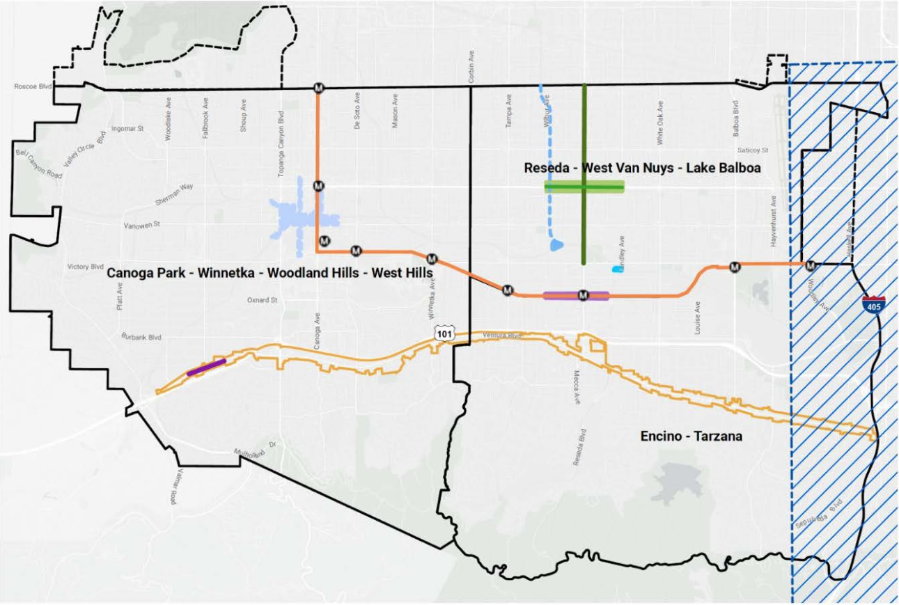
In response to this program change, the Southwest Valley Community Plan Updates Unit plans to conduct outreach in early 2022, which would provide updates to the Proposed General Plan Land Use Map we released in December 2020. We will be in touch in the near future with more information regarding future engagement opportunities for the Southwest Valley Community Plans Update, which includes updates to the Canoga Park - Winnetka - Woodland Hills - West Hills, Encino - Tarzana, and Reseda - West Van Nuys Community Plan Areas.
El Departamento de Planeación de Los Ángeles (Los Angeles City Planning, LACP) anunció recientemente que para apoyar la recuperación de Ventura Boulevard después de la pandemia, la Unidad de Enmienda al Plan Específico de Ventura-Cahuenga se enfocará en los temas de interés inmediato para los negocios y otras partes interesadas del Corredor. Esto incluye la simplificación de los permisos de letreros, la modernización de los gastos de la tarifa de Valoración del Impacto de Proyecto (PIA, por sus siglas en inglés), y la mejora de la movilidad por todo el Corredor, para asegurar que los negocios reciben la ayuda necesaria. El equipo organizará eventos virtuales de alcance público sobre las últimas propuestas para las fechas del 27 de octubre y el 2 y el 4 de noviembre; para más información haga clic aquí.
El Departamento de Planeación abordará la aplicación del nuevo Código de Zonificación a la Enmienda al Plan Específico del Corredor de Ventura-Cahuenga Boulevard como parte de la actualización de los planes comunitarios ya en curso en el Suroeste del Valle. Este enfoque significa una utilización más efectiva de los recursos de la Ciudad y apoyo para la zonificación adaptada que respeta las prioridades de cada comunidad. Este cambio en el programa es una oportunidad para usar un enfoque integral a la planeación de uso de suelo en los alrededores del corredor de Ventura Boulevard. Los planes comunitarios buscan establecer el uso de suelo en función de la infraestructura próxima, responder a los cambios en las condiciones del mercado y los pronósticos demográficos, y crear oportunidades para la vivienda y el empleo. La inclusión de la planeación de Ventura Boulevard en este esfuerzo es un paso razonable para crear un plan de uso de suelo integrado que refleja una visión colectiva para el Suroeste del Valle.
En respuesta a este cambio en el programa, la unidad de Actualización de los Planes Comunitarios del Suroeste del Valle realizará actividades de alcance público en los primeros meses del 2022, con actualizaciones al Mapa Propuesto de Uso de Suelo del Plan General que fue publicado en diciembre del 2020. Estaremos en contacto dentro de poco con más información sobre las oportunidades de alcance público del programa de Actualización de los Planes Comunitarios del Suroeste del Valle, que incluye actualizaciones al plan de Canoga Park - Winnetka - Woodland Hills - West Hills, el plan de Encino - Tarzana, y el plan de Reseda - West Van Nuys.
Investment Map
In addition to the Community Plans Update, the Southwest Valley is experiencing investments in transit, streetscape, and public open space access projects from different regional and local agencies as well as community and neighborhood organizations. View the map below to view these local investments. The map includes links for additional information about each investment.
View the Fact Sheet and Frequently Asked Questions, the existing Ventura-Cahuenga Boulevard Corridor Specific Plan, and the Community Plan Updates. Other documents, related links, and outreach materials will be uploaded here as they become available during the amendment process.
PCTS Page
Documents and Information for the Planning Case No. CPC-2023-1637-SP
FAQ
Please click here to view the Fact Sheet and Frequently Asked Questions.
Event Materials
Learn about past events such as the Information Session and Public Hearing.
Existing Specific Plan
Learn more about the existing Ventura-Cahuenga Boulevard Corridor Specific Plan as adopted.
Southwest Valley Community Plan Update
Click below to learn more about the Canoga Park-Winnetka-Woodland Hills-West Hills Community Plan and the Encino-Tarzana Community Plan which include a portion of the Ventura Cahuenga Boulevard Corridor Specific Plan.
Southeast Valley Community Plan Update
Click below to learn more about the Sherman Oaks – Studio City – Toluca Lake – Cahuenga Pass Community Plan which includes a portion of the Ventura Cahuenga Boulevard Corridor Specific Plan.
Ventura Winter Survey Results
Results are available for the survey regarding Ventura sidewalks and the public right-of-way which closed in March 2022
The Draft Wildlife Ordinance has drawn extensively from local knowledge and subject area expertise. The resources below are among the many references, guidelines, and tools that have informed the project.
Draft Wildlife Ordinance
Current Draft
- Draft Wildlife Ordinance (Approved by City Attorney as to Form and Legality) (November 2024)
- Wildlife Ordinance Staff Report Appendices (December 2022)
- Protected Areas for Wildlife and Wildlife Movement Pathways Final Report (February 2021)
- This report identified potentially ecologically sensitive areas in the City of Los Angeles. Produced by a consultant team of biologists, the report helped to inform the Wildlife Pilot Study and Draft Wildlife Ordinance.
Previous Drafts
- Draft Wildlife Ordinance revised with City Planning Commission recommendations (December 2022)
- Wildlife Ordinance Staff Report Exhibits (December 2022)
- Staff Recommendation Report to CPC (December 2022)
- Revised Draft Wildlife Ordinance (April 2022)
- Draft Wildlife Ordinance (May 2021)
Factsheets
- August 2023 Fact Sheet
- Revised Wildlife Ordinance - Summary and Changes
- Wildlife Ordinance Sources Consulted
- July 2022 Wildlife Ordinance Fact Sheet
- 2022 Revised Draft Wildlife Ordinance Fact Sheet
- Wildlife Pilot Study and Draft Wildlife Ordinance FAQ (April 2021)
- Protected Tree & Shrub Regulations
- Biodiversity Fact Sheet (February 2022)

Workshop Resources
Introducing Los Angeles as part of a biodiversity hotspot and establishing other background ordinance concepts.
- 2021 Virtual Workshop Recording
- 2019 Workshop Display Boards
- 2019 Workshop Survey
- 2018 Workshop Display Boards

Media
- Channel 35 LA This Week - Overview of the Importance of the Wildlife Ordinance
- Channel 35 LA This Week - City Planning Keeps Wildlife in Mind Alongside Urban Development
- April 2022 Draft Wildlife Ordinance Informational Video - Part 1: Importance of the Ordinance
- April 2022 Draft Wildlife Ordinance Informational Video - Part 2: Ordinance Background and Overview
- 2021 Informational Video
LASAN Biodiversity Initiative
The City of Los Angeles has an entire initiative dedicated to monitoring progress toward the no-net loss of biodiversity target.
Brush Fire Prevention
This Los Angeles Fire Department site has important information about maintaining fire-safe landscapes.
Sustainable Defensible Space
The Resources Conservation District of the Santa Monica Mountains and many key regional partners created this site to guide eco-appropriate home-scaping for wildfire resilience.
California Invasive Plant Council
Cal-IPC keeps a close watch on invasive plants and maintains an inventory that categorizes plants that threaten California's natural areas.
iNaturalist
The iNaturalist platform is an important interactive resource for producing community science data about local plants and wildlife.