About

Missing Middle LA is a new Los Angeles City Planning initiative to make both for-sale and rental housing more accessible by streamlining the City’s review process and removing barriers to building smaller, neighborhood-scale homes – also known as “missing middle” housing. The program will implement and build upon recent state laws allowing duplexes, small-lot townhomes, and for-sale of Accessory Dwelling Units (ADUs) in all residential zones. Rather than a one-size-fits-all program, Missing Middle LA will offer a context-sensitive approach tailored to the unique policy priorities of Los Angeles.

Why Missing Middle LA?

With LA’s median home price in excess of $1 million, homeownership is out of reach for most Angelenos. Only 36% of LA residents own a home. This is one of the lowest rates in the US. These trends place enormous pressure on working families, young adults, and longtime residents who want to stay in the city they call home. Missing Middle LA is designed to address this challenge by opening new pathways for Angelenos to stay rooted in their communities in line with the City’s Housing Element goals.

The program will incorporate recommendations and lessons learned from the Department’s Low-Rise Design Lab, an initiative that began in 2024 to analyze real world lot configurations and address the regulatory and economic barriers inhibiting development of missing middle housing.

The Missing Middle LA initiative will be implemented through targeted zoning code amendments organized around three pillars:


A second draft of the proposed Missing Middle LA Ordinances along with the Objective Design Standards for Small Lot Homes were released in September 2026. They are available for public review and comment in the Resources tab. Planning staff will also conduct a Virtual Webinar and Public Hearing on October 1st, 2026 to receive public testimony on the proposed Missing Middle LA draft ordinances. The combined webinar and hearing will provide an opportunity for members of the public to learn more about the proposals and share comments directly with Planning staff.

The Missing Middle LA program is being funded by a Regional Early Action Planning (REAP) 2.0 grant that Los Angeles City Planning received from the Southern California Association of Governments (SCAG). The REAP 2.0 grant deadline for this project is December 2026.

Web Banner Image by Charles Young.

SCAG (logo) is the nation’s largest Metropolitan Planning Organization (MPO).


Westside Community Plans

Los Angeles City Planning is in the process of updating its 34 Community Plans. The plans constitute the Land Use Element of the General Plan, the long-range planning document that presents the City’s vision for the future of its neighborhoods. The Department incorporates input from the community into its policies and programs, which will guide development and growth in Los Angeles's neighborhoods for years to come.

As part of this process, the Department is concurrently updating the four Community Plan Areas on the Westside listed below. These updates are shaped with local stakeholders to create a vision tailored to the Westside’s needs, reflecting current and future conditions related to land use, housing, employment, transportation, urban design and compatibility, environmental protections, and other key factors. Once adopted, each community plan area will include an updated long-range policy document, a zoning map, and the application of the City’s new zoning code that went into effect in 2025.

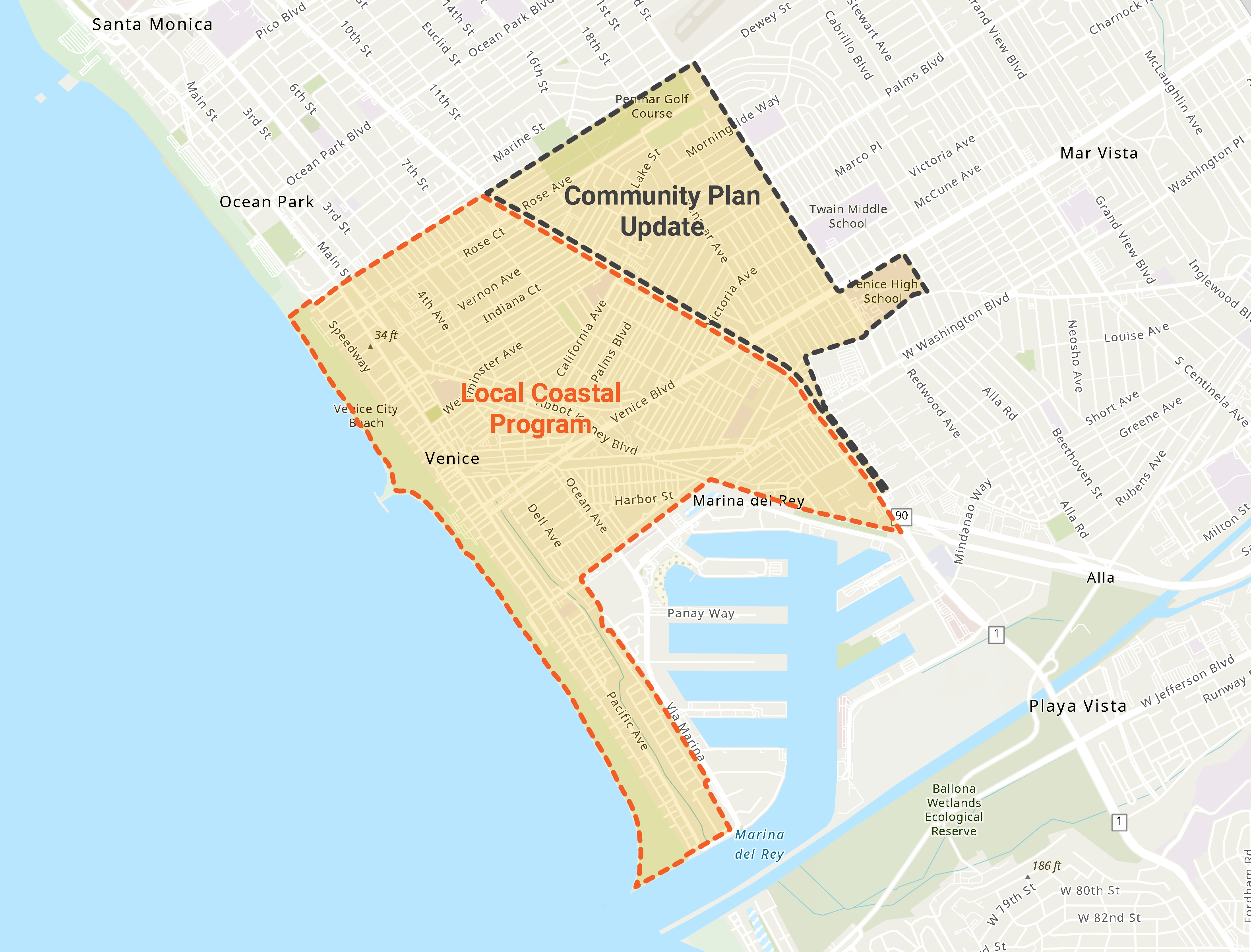
Community Plan Areas Map-thumb


Outreach Timeline

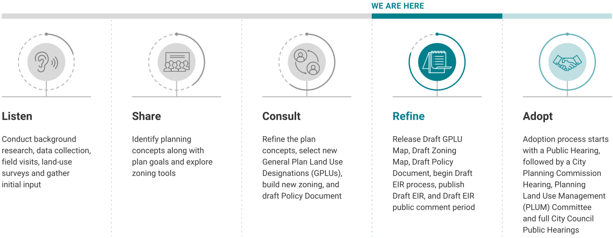
The Westside Community Plans Update is a multi-year program which began in 2018. Below is the current timeline, outlining the key steps in the process.


In response to the devastating Palisades Fire, Governor Gavin Newsom and Mayor Karen Bass have issued a series of Emergency Executive Orders. These orders streamline and expedite the permitting process to allow for the rapid rebuilding and repair of homes, businesses, and other structures that were destroyed or damaged as a result of the disaster. The Orders establish criteria for by-right rebuilds, called Eligible Projects, that are not subject to the California Environmental Quality Act (CEQA) or the Coastal Act.

Consistent with the directives in the Orders, City Planning is committed to facilitating quick and streamlined rebuilding of the Palisades community and bringing businesses back in operation as quickly as possible. City Planning is assisting in these key ways:

  • Fast-tracking all Eligible Projects as defined by the Orders with most not requiring a City Planning review
  • Expediting initial permit reviews for projects involving structures damaged or destroyed by the Wildfires that are Non-Eligible Projects
  • Assessing the status of historic resources affected by the recent events

In addition to the Orders related to physical rebuilding and recovery, Mayor Karen Bass also issued Emergency Order 4 that aids in the relocation, co-location, and temporary operation of educational and child care facilities that were adversely impacted by the Wildfire. See EO4 Implementation Guidelines for more information.  Mayor Bass has also issued Emergency Order 9 to suspend SB9 projects in the Palisades.

Emergency Executive Order 1
 

Mayor Bass’s Executive Order 1 (EO1) streamlines and expedites the permitting process to allow for the rapid rebuilding of the Palisades.

To guide applicants, City Planning, the Los Angeles Department of Building and Safety (LADBS), the Los Angeles Housing Department (LAHD), and the City of Los Angeles Bureau of Engineering (BOE) have created EO8 Implementation Guidelines that outline rebuilding procedures and requirements.

Emergency Executive Order 8
 

Mayor Bass’s Executive Order 8 (EO8) provides additional streamlining for the permitting of single-family houses in the Palisades.

To guide applicants, City Planning, the Los Angeles Department of Building and Safety (LADBS), the Los Angeles Housing Department (LAHD), and the City of Los Angeles Bureau of Engineering (BOE) have created EO8 Implementation Guidelines that outline rebuilding procedures and requirements.

Emergency Executive Order 10
 

Mayor Bass’s Executive Order 10 (EO10) streamlines permitting procedures for commercial projects in the Pacific Palisades Commercial Village Specific Plan area. EO10 can be applied to projects involving properties that were or were not damaged or destroyed by the fire.

The New South LA Development Services Center

It is a racial equity goal of the LA City Planning Department and the LA City Council to have a physical Planning presence in South Los Angeles. The new South Los Angeles Development Services Center (DSC) allows the Department to bring a Planning counter and other vital services closer to the South LA community and surrounding areas.

More Equitable Access to Planning

A legacy of inequities including racialized policies - from redlining and zoning to urban renewal have contributed to the disenfranchisement of South Los Angeles. The lack of diverse and inclusive community stakeholder involvement in urban planning policy and development decisions have oftentimes contributed to poor outcomes for this community.

The South Los Angeles Development Services Center, consisting of traditional planning services along with a community engagement component, is critical to racial equity for area residents and applicants. In addition, South LA and Harbor LA community stakeholders finally have convenient access to a Planning counter providing an opportunity to schedule an in-person appointment with a Planner to file cases, obtain information or assistance with navigating through challenging Planning policies, procedures and regulations. This level of convenience and accessibility is unprecedented for this community.

One-Stop Services Offered

The South Los Angeles DSC is located on the first floor of the Council District No. 8 (CD 8) Constituent Service Center, 8475 Vermont Avenue. The Los Angeles Department of Building and Safety (LADBS) and Housing Department also operate public counters at this location. This provides a one-stop shop experience for applicants to meet with a planner to receive assistance and with staff from LADBS during the same visit.

Please note separate appointments must be made to meet with staff at LADBS and Housing through their websites.

Schedule an Appoinment
 

The City’s new BuildLA portal offers appointments and assistance with development services.

Location and Hours
 

The public counter is where planning and development come together and the land use process typically begins.

Summary

In anticipation of the construction of Metro’s East San Fernando Valley Light Rail Transit Project (ESFV LRT), and in response to a City Council Motion by Council District Offices 6 and 7 (Council File No. 19-1289), City Planning has launched the East San Fernando Valley Transit Neighborhood Plan (ESFV TNP) work program. The ESFV TNP will align with citywide policies that support housing, equity and sustainability while tailoring strategies to the context and needs of the Northeast Valley. The plan aims to support transit ridership and mobility access, expand future affordable housing opportunities, and support economic vitality throughout the project area. To implement these policies and strategies, the ESFV TNP Team will propose new land use designations and zoning regulations for adoption along the Van Nuys Boulevard Corridor, specifically in areas within the communities of Pacoima, Arleta, and Panorama City. The distinct areas surrounding each station will be planned contextually, in partnership with community members and stakeholders throughout the TNP process.

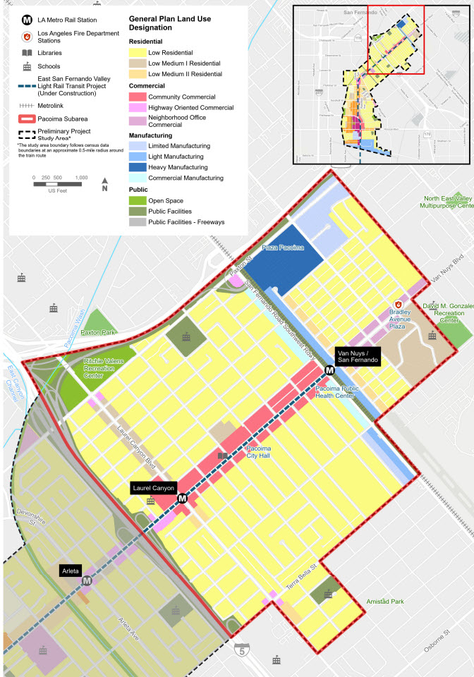
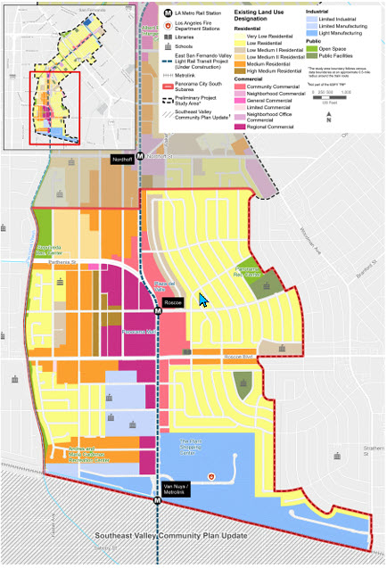
The preliminary project study area focuses on an approximately half-mile buffer along the Van Nuys Corridor, between the Van Nuys/Metrolink station to the south and the Van Nuys/San Fernando station to the north (see map below), which is all part of the initial light rail segment Metro expects to be operational by 2031.

This multi-year work program initiated the first phase of public engagement and outreach events during the spring of 2023 (see project timeline below). City Planning will post details of upcoming opportunities for engagement as outreach continues. For more information, please review the Fact Sheet, which includes responses to Frequently Asked Questions. Complete the sign-up form here to receive email and/or text updates.

Please note that the ESFV TNP is a City Planning land use policy and zoning update effort. For inquiries about Metro rail construction or the status of other Metro transit projects, please click here to visit Metro's website.

Preliminary Project Study Area

Currently, the preliminary study area follows census data boundaries at an approximate half-mile buffer around the train route. The study area is not final and could be adjusted in the future.


map


Project Timeline

The ESFV TNP is a multi-year work program that will involve opportunities for public participation at every phase of the process. As part of the "Listen Phase," the ESFV TNP Team has been spreading awareness about the program, building relationships with local organizations, and sharing educational materials so community members have the foundational knowledge needed to meaningfully participate in the planning process. While engagement in the "Listen Phase" will continue throughout 2024, staff are concurrently beginning to draft land use maps which will tentatively be released in Spring 2025.
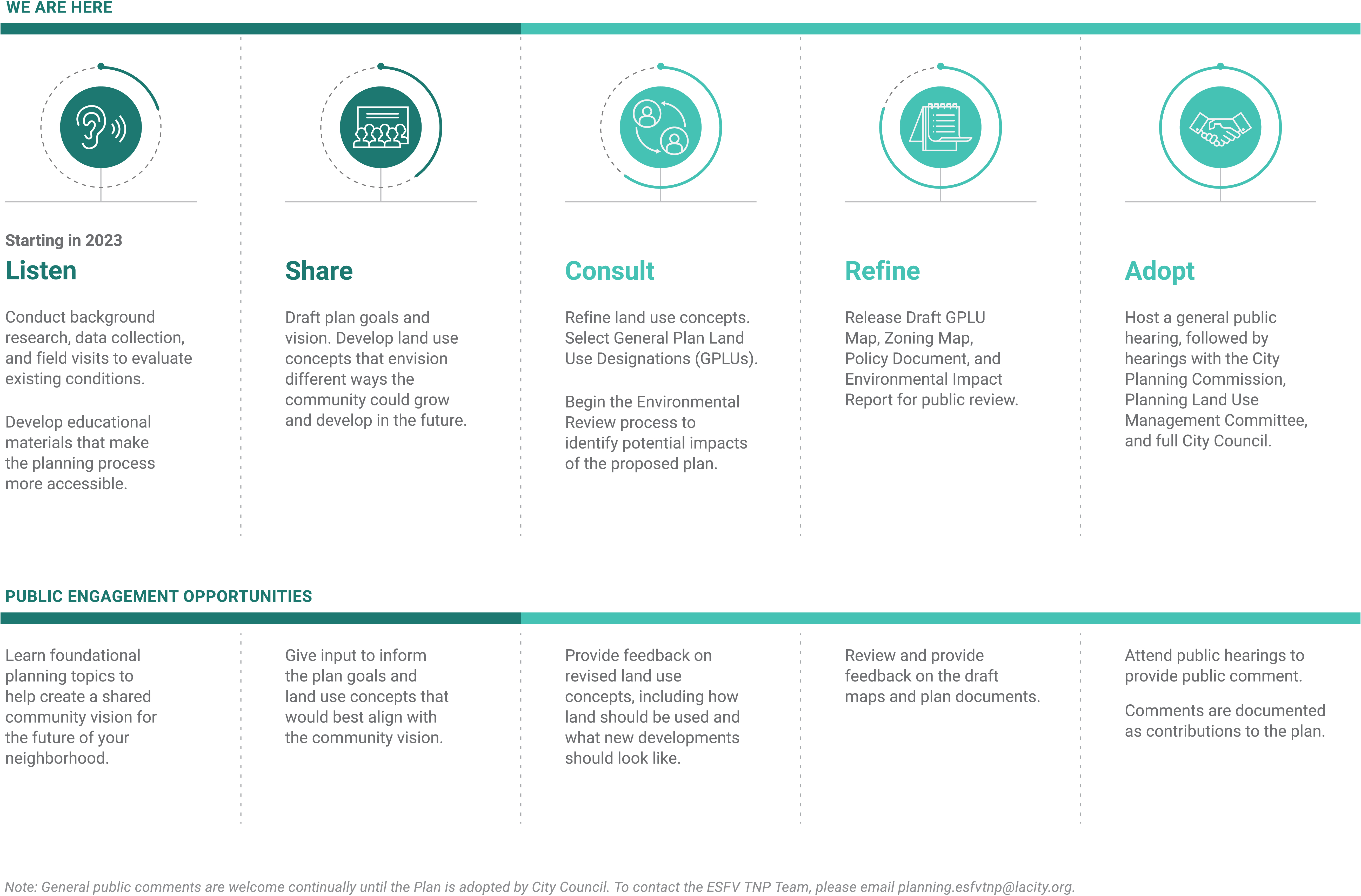
ESFV TNP Timeline

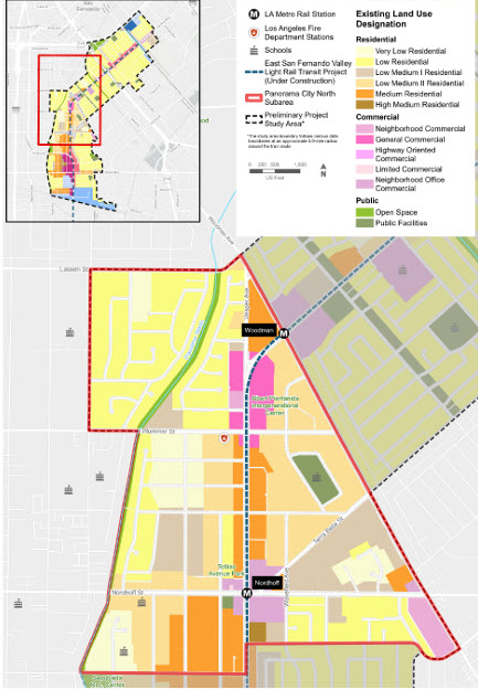
Existing Conditions

The preliminary project study area overlaps with the train route and encompasses parts of the Pacoima, Arleta, and Panorama City communities. For analysis purposes, these areas are referred to as “Subareas.” To learn more about each Subarea, please click on the dropdowns below.

Subscribe to About