About

The State of California and the Los Angeles City Charter require the City to maintain a General Plan that sets the long-range vision for the physical development of the city. The General Plan is structured into various chapters, known as Elements, each focusing on a different aspect of the urban environment. The General Plan must include nine mandatory Elements (such as Land Use, Safety, Housing, and Noise) but each jurisdiction has the ability to reorganize the Elements or include additional Elements based on needs and values. Each Element contains goals, policies, and programs that guide decision making and establish the future form and development of the City.

The General Plan provides guidance on where and how the City responds to and prepares for change. While the General Plan is maintained and updated by City Planning, it reflects the work and policy direction for all City departments. It is the foundation City departments and the City Council use to determine policy priorities and make informed decisions pertaining to land use and development.


The City of Los Angeles is currently updating the Community Plans for the three Community Plan Areas of the Southeast Valley: North Hollywood-Valley Village, Sherman Oaks-Studio City-Toluca Lake-Cahuenga Pass, and Van Nuys-North Sherman Oaks.

The plans constitute the Land Use Element of the General Plan, the long-range planning document that presents the City’s vision for the future of its neighborhoods. The Land Use Element of the City’s General Plan consists of 34 Community Plans. Their purpose is to guide future growth in the City’s communities, based on knowledge of current conditions, projected demographic changes, and the priorities of residents and other stakeholders.

Through the Community Plan update process, the Planning Department works with community stakeholders to develop a vision unique to the Southeast Valley’s needs based on current and anticipated conditions related to land use, housing, jobs, transportation, environmental protection, and other factors. When finished, each Community Plan consists of both a long-range policy document and a zoning map. Watch this short video explaining Community Plans.

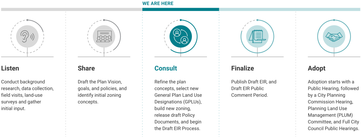
Outreach Timeline

The multi-year update process began in July 2018. It will culminate in the City Council’s adoption of the Community Plans. Below is the current timeline for the Southeast Valley Community Plans Update. Please sign up for updates on our Contact page.


Environmental Justice Policy Work Programs

As a continued effort to recognize impacted communities and acknowledge historical needs to address environmental justice in Los Angeles, City Planning’s Environmental Justice Policy Team has embarked on a comprehensive effort to centralize and strengthen environmental justice policies in the City’s General Plan. Los Angeles’ General Plan prescribes policy goals and objectives that inform land use decisions, and ultimately shape and guide the physical development of the City. The Environmental Justice Policy Work Programs include General Plan updates and extensive community outreach and engagement that address issues related to land use, sustainability, climate equity, open space and environmental justice.

Three separate environmental justice work programs were initiated in 2023-2024 to help develop an equitable and transformative policy framework: the Climate Vulnerability Assessment, the Health and Environmental Justice Element Update and the Open Space Element Update.

Please see below for the current status of these department work programs:

  • Open Space Element Update: This multi-year work program is ongoing and will continue to advance through the update process. Public feedback on a preliminary draft of the Open Space Element was collected through March 31, 2026. This input will be used to develop an updated version of the element as it progresses toward the adoption phase. More information is available on the Department’s Open Space page.
     
  • Climate Vulnerability Assessment (CVA): The CVA has been completed and is available on the Department’s Climate Equity page.
     
  • Health and Environmental Justice Element Update:  The City's adopted budget for fiscal year 2025-2026 included the elimination of the Health and Environmental Justice work program and as a result, this work was discontinued in October 2025 after the second phase of outreach and engagement concluded. More information is available on the Department’s Health & EJ page.
     

Summary

The Environmental Justice (EJ) Policy Program was launched in August 2023. The Health and Environmental Justice Element work program was intended to combine the existing Health and Air Quality Elements to centralize and strengthen environmental justice policies in the City’s General Plan. The targeted update of the Open Space Element was initiated on a parallel track to address climate resilience, environmental justice and rewilding. A Climate Vulnerability Assessment for the City was also conducted to inform the Department’s overall approach to policy development and future climate planning efforts.

Background

Environmental justice is defined in State law as the “fair treatment and meaningful involvement of people of all races, cultures, incomes, and national origins, with respect to the development, adoption, implementation, and enforcement of environmental laws, regulations, and policies.”1 The principle of environmental justice ensures equal and equitable protection from environmental and health hazards, while giving people fair and equal access to the planning and decision-making process.

The General Plan includes existing policy language that calls for the benefits of growth and investment be distributed equitably, while also ensuring that the costs are not disproportionately borne by over-burdened and under-resourced groups. Recent efforts led by City Planning to implement policies and programs that center on health and environmental justice include the recent adoption of the Oil and Gas Drilling Ordinance and the development of the draft Landscape and Site Design Ordinance to advance healthy building design and climate-adapted site design standards in the City.

However, residents in many of the City’s lower income neighborhoods continue to be more likely to live next to noxious land uses, truck routes, and other environmental hazards that affect their health. Combined with poor social and economic environments, many communities face the cumulative burden of risk and impact that may be addressed through a focus on public health and environmental justice. A commitment to environmental justice includes ensuring meaningful community participation in the planning process to promote equity and representation for underserved communities.

1The full definition of “environmental justice” in California State Law is found in California Government Code Section 65040.12(e). The Federal EPA defines environmental justice similarly; the full definition can be found at: http://www.epa.gov/environmentaljustice/


The Orange (G) Line

The Orange (G) Line Transit Neighborhood Plan, also referred to as the Orange Line TNP or OLTNP, is a long-range planning effort around three Metro Orange (G) Line stations in the eastern San Fernando Valley. As part of the Transit Neighborhood Plans, Los Angeles City Planning is developing regulatory tools and strategies for the areas around the Van Nuys, Sepulveda, and North Hollywood Stations along the Metro Orange (G) Line. These tools and strategies aim to create more housing options and job opportunities in proximity to transit. Directing growth to these areas is an overarching principle of the City’s General Plan, and aligns with broader efforts to reduce automobile dependency and greenhouse gas emissions. Each station area is distinct and will be planned with contextual intensities, land uses, design standards, and other strategies.

The Metro Orange (G) Line is an 18-mile Bus Rapid Transit (BRT) line that operates in the San Fernando Valley. Bus service operates between the Chatsworth Metrolink Station in the Northwest Valley and the North Hollywood Metro Red (B) Line Station in the Southeast, which connects the San Fernando Valley to Downtown Los Angeles. Originally opened in 2005 and expanded in 2012, the line uses a dedicated bus right-of-way separated from street traffic for the entirety of the line length, part of which utilizes a former railroad track. The Orange (G) Line is one of the busiest bus rapid transit lines in the nation. The stations included in the OLTNP have among the highest ridership on the Orange (G) Line. For more information from Metro on the Orange (G) Line, please visit here.

Additionally, Los Angeles City Planning recently adopted a comprehensive revision to the City’s Zoning Code. Each new Community or Transit Neighborhood Plan project is developing new zones. Coupling the zoning code revision with the plan updates provides the department with an opportunity to create policies and implementation tools tailored to each station area, while supporting transit ridership, pedestrian-orientation, and sustainable neighborhoods throughout the San Fernando Valley. Transit Neighborhood Plans for the Orange (G) Line focus on three stations (see below).

Plan Goals

The following Goals represent the long-term priorities for the OLTNP Station areas. They reflect what we've heard through our outreach and topics that have arisen through technical research. Please provide your input on these as they are not yet finalized, and will inform the updated Plan policy documents.

  • Promote a variety of housing options for people of all income levels near transit
  • Create mixed-use neighborhoods with community serving businesses and amenities
  • Connect people to a variety of mobility options and promote and sustain transit ridership
  • Implement quality design standards that support a healthy and safe public realm
  • Support strategies that address the Valley’s climate and promote sustainable living

The City of Los Angeles was awarded a grant through Metro’s Transit Oriented Development (TOD) Planning Grant Program to partially fund this effort. The grant program supports planning efforts that enhance access to transit, reduce greenhouse gas emissions, and promote sustainable development. The Reseda Boulevard and Sherman Way stations were initially included as part of the OLTNP program. In 2018, they were removed from the OLTNP and are currently being rezoned as a component of the Southwest Valley Community Plan Updates Program.

Metro Logo

What is a Transit Neighborhood Plan (TNP)?
 

The Transit Neighborhood Plan (TNP) Program encourages the growth of livable communities and employment centers around the region’s expanding transit network. Click below to read more about LA City Planning’s Transit Neighborhood Plans.

Frequently Asked Questions (FAQs)
 

Click below for quick answers to frequently asked questions about the Orange (G) Line Transit Neighborhood Plan.

Senate Bill 9 (SB 9), the Housing Opportunity and More Efficiency (HOME) Act, is a 2021 California law that aims to increase housing supply across the State by requiring a streamlined ministerial approval process for urban lot splits and/or two-unit developments in single-family zones. The HOME Act was subsequently amended by SB 450 in 2024 and Assembly Bill 1061 in 2025. This webpage and all associated materials have been updated to reflect these changes.

For planning inquiries related to SB 9, email planning.SB9@lacity.org. For additional resources, please see the Resources & Contact tab.

Key Components

Two Unit Developments
Permits and streamlines the process for the development of two primary dwelling units on single-family zoned lots

Urban Lot Splits
Permits and streamlines the process for subdividing an existing single-family zoned lot into two individual parcels without having to meet the minimum lot size required by the underlying zone

Development Scenarios

These examples illustrate some of the most common development scenarios and do not represent every possible lot/unit configuration.

Urban Lot Splits

Lot Split with two new rectangular parcels and a Single Family Dwelling (SFD) on each lot

Lot split with flag lot configuration with SFD and Junior Accessory Dwelling Unit (JADU) on one lot and an SFD and a detached Accessory Dwelling Unit (ADU) on the other lot


Two Unit Developments

2 SFDs + 1 detached ADU

Duplex + 1 detached ADU

2 SFDs + 1 JADU

Duplex + 2 detached ADUs

Urban Lot Splits & Two Unit Developments

Duplex on each lot

Duplex on one lot and 2 SFDs on one lot


Subscribe to About